

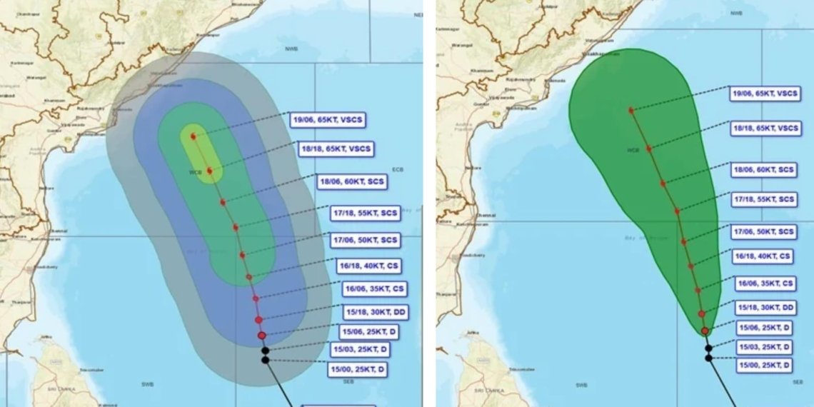
Bhubaneswar: A developing weather system over the Bay of Bengal is raising concerns along the Andhra Pradesh–Odisha coastline, with the India Meteorological Department (IMD) warning of a possible intensification into a very severe cyclonic storm in the coming days.
The depression over the southeast and adjoining southwest Bay of Bengal is moving north-northwestward and is expected to gain strength progressively. According to IMD Bhubaneswar Regional Centre Director Dr Manorama Mohanty, the system could intensify into a deep depression on Sunday, a cyclonic storm by November 16 and a severe cyclonic storm by November 17. It may further develop into a very severe cyclonic storm by the morning of November 19.
The system is forecast to move towards the Andhra Pradesh coast, while Odisha is likely to experience widespread weather disturbances. At its peak, wind speeds over the sea could reach 120–130 kmph, with gusts up to 145 kmph.
Odisha Weather Alert: Rainfall Expected From November 18
Odisha is likely to experience largely dry weather until November 17. However, rainfall activity is expected to increase from November 18, with coastal and interior districts coming under the influence of the system.
November 18: Light to moderate rainfall and thunderstorms are likely in several districts. Gajapati, Ganjam and Puri have been placed under a Yellow Warning for heavy rainfall.
November 19: An Orange Warning has been issued for Gajapati, Ganjam and Puri, where very heavy rainfall and winds of 50–60 kmph are expected. Several other districts, including Balasore, Bhadrak, Cuttack, Khordha, Kendrapara, Jajpur, Koraput and Malkangiri, are under a Yellow Warning.
November 20: Rayagada, Koraput, Malkangiri, Gajapati and Ganjam remain under an Orange Warning.
November 21: The weather alert shifts towards western Odisha, with Sundargarh, Jharsuguda and Bargarh placed under an Orange Warning.
Thunderstorms and widespread rainfall are likely across several parts of the state between November 19 and 21.
Strong Winds and Rough Seas Raise Coastal Concerns
The IMD has also issued warnings for fishermen and coastal communities.
Wind speeds along the southern Odisha coast may reach 40–50 kmph from November 17, increasing to 50–60 kmph between November 18 and 20.
Conditions over the central Bay of Bengal could deteriorate further, with wind speeds potentially reaching 100–130 kmph from November 18. The sea is expected to remain very rough to high along the Odisha coast between November 17 and 21.
Fishermen Advised to Stay Away From Sea
Fishermen have been advised to return to shore and strictly avoid venturing into the sea during the warning period. Fishing operations have been prohibited in the southwest and central Bay of Bengal and along the southern Odisha coast.
Authorities Asked to Remain on High Alert
The developing cyclone threat could bring significant disruption, particularly in vulnerable coastal and hilly areas.
Possible impacts include uprooted trees, damage to temporary houses, disruption of electricity and communication networks, waterlogging, road blockages and localised landslides in vulnerable hilly regions.
With the weather system continuing to strengthen, authorities are being urged to remain prepared and closely monitor its movement.
The next few days will be crucial as Odisha and neighbouring Andhra Pradesh remain on alert for the approaching cyclonic system.
